GIS forFoundation Data
Expect more from your mapping investment
Esri’s platform allows you to collect data once and reuse it many times. Manage the integrity of your data efficiently and use it on demand. Produce the high-quality, authoritative cartographic and topographic maps, data, and services your organization needs to succeed. Develop strategic mapping products for your customers to help them solve local and national problems.
Solutions
Use reliable workflows and tools in Esri's platform to collect, maintain, and publish your data with the highest integrity. Update your long-term project maps in real-time with a single application.
|
|
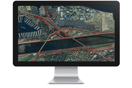
ArcGIS for Desktop Creating accurate, actionable map products requires a comprehensive production platform to facilitate precise data collection, analysis, and distribution. With ArcGIS for Desktop, mapping agencies and production departments can build their databases from multiple sources and formats. Robust workflows can process this data at multiple scales for analysis or delivery, depending on your needs. |
| Esri Production Mapping Create and maintain large amounts of authoritative geospatial maps, charts, and data for multiple uses. Achieve economies of scale by managing and publishing consistent GIS data and cartographic products on strict schedules. |
|
|
|
Esri Defense Mapping Produce and maintain high-quality topographic databases and cartographic products for military and civil authorities. Efficiently manage production workflows and the foundation data used for topographic products and analysis. |
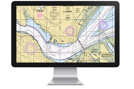
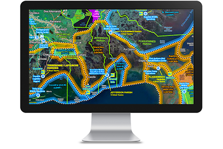
A Marine Spatial Data Infrastructure (MSDI) delivers a strategic solution for data production and management to national hydrographic organizations, commercial chart producers, and naval commands. Esri's mapping and charting platform enables enterprises to easily implement an MSDI. Perform data input, formatting, geoprocessing, map creation, and analytics using one scalable system.
|
|
ArcGIS for Maritime: Charting ArcGIS for Maritime: Charting helps national hydrographic offices, charting agencies, and subcontractors significantly increase the speed and flexibility of their production operations. The solution provides a true GIS-based platform to improve, standardize, and expedite data and workflow management. |
| ArcGIS for Maritime: Bathymetry ArcGIS for Maritime: Bathymetry is an extension to ArcGIS for Desktop that makes it easy to manage and combine massive amounts of bathymetric data and metadata in a GIS environment. The solution provides spatial analysis tools that let you realize the true value of bathymetric data by making it GIS enabled. |
|
|
|
ArcGIS for Desktop Creating accurate, actionable map products requires a comprehensive production platform to facilitate precise data collection, analysis, and distribution. With ArcGIS for Desktop, maritime mapping agencies and cartographic professionals can build their databases from multiple sources and formats. Robust workflows can process this data at multiple scales for analysis or delivery, depending on your needs. |
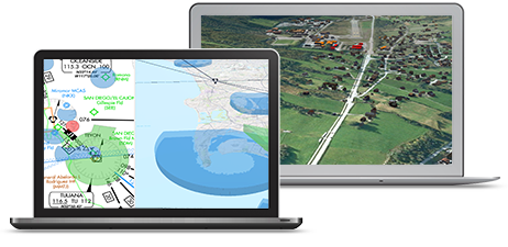
Safer navigation requires accurate aeronautical information. Esri’s scalable charting platforms enables you to manage aviation data, products, services and workflows. Take advantage of standards-based geospatial tools to build and update your data without sacrificing its integrity. Esri technology helps you meet your rigorous requirements while solving problems and improving efficiency.
|
|
ArcGIS for Aviation: Airports Airports and their consultants use ArcGIS for Aviation: Airports to comply with the data management and quality standards established by national aviation authorities throughout the world. Efficiently manage data, automate quality control, and extend visualization capabilities to speed map production. |
| ArcGIS for Aviation: Charting Aviation chart producers, airlines, and airport authorities can create, maintain, and distribute standard aeronautical products with ArcGIS for Aviation: Charting. Data can be easily exchanged using the Aeronautical Information Exchange Model. |
|
|
|
ArcGIS for Desktop Aviation authorities require a comprehensive chart production platform to facilitate precise data collection, analysis, and distribution. With ArcGIS for Desktop, you can build databases from multiple sources and formats. Robust workflows can process this data at multiple scales for both analysis and delivery. |
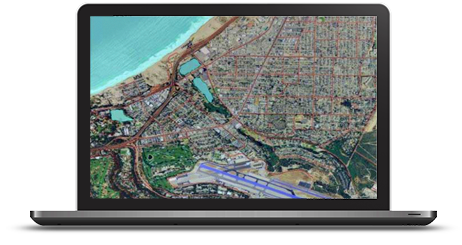
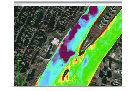
Organizations need to take advantage of imagery, lidar and other remotely sensed content to provide a timely and accurate picture. Using ArcGIS you can quickly update your GIS data so you can spend more time performing priority analytics. The ArcGIS platform allows you to see your imagery and lidar in 2D and 3D, find the patterns and anomalies, and share your results with others.
|
|
ArcGIS for Desktop Extract information from imagery and lidar, and perform advanced GIS analytics. Visualize your data and perform spatial analysis that can help you better understand your project. Share data and analysis results with colleagues and constituents to facilitate dialogue for business, local and regional issues. |
| Drone2Map for ArcGIS This desktop app turns raw still imagery from drones into orthomosaics, 3D meshes, and more, in ArcGIS. Create 2D and 3D maps of hard-to-access areas. Monitor change, perform land analysis and inspections. Drone2Map helps you unlock insights hidden in your imagery. |
|
|
|
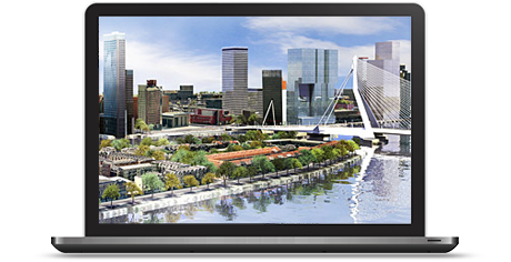
Esri CityEngine Improve urban planning, architecture, and design with 3D visualization tools. Analyze the relationship between new and existing projects. Assess the feasibility of proposed projects and plan its construction. Make redevelopment decisions that can benefit your community for decades. |

Use reliable workflows and tools in Esri's platform to collect, maintain, and publish your data with the highest integrity. Update your long-term project maps in real-time with a single application.
|
|
ArcGIS for Desktop Creating accurate, actionable map products requires a comprehensive production platform to facilitate precise data collection, analysis, and distribution. With ArcGIS for Desktop, mapping agencies and production departments can build their databases from multiple sources and formats. Robust workflows can process this data at multiple scales for analysis or delivery, depending on your needs. |
| Esri Production Mapping Create and maintain large amounts of authoritative geospatial maps, charts, and data for multiple uses. Achieve economies of scale by managing and publishing consistent GIS data and cartographic products on strict schedules. |
|
|
|
Esri Defense Mapping Produce and maintain high-quality topographic databases and cartographic products for military and civil authorities. Efficiently manage production workflows and the foundation data used for topographic products and analysis. |
Philippine Statistics Authority needs to provide authoritative, trustworthy data about a nation’s population. Geography is at the heart of this information. From planning and collection to analysis and dissemination, location plays a critical role. There is an increasing demand for location-based information about places, people, human activity, business, economic growth, and health. Esri GIS allows you to recognize and understand socio economic information by linking it to location.
|
|
ArcGIS Platform Create and manage data, conduct analysis, and share findings. With ArcGIS you’ll improve operations, collaboration, and citizen engagement. ArcGIS as a platform provides open geospatial capabilities to any user and allows access by any application on any device anywhere, anytime. |
| ArcGIS Online Maps are a central part of any NSO workflow - from planning to collection to dissemination. By using dynamic web maps, you can discover, consume, create, and share geospatial content, maps, and data within groups and across divisions. You can also use dynamic web maps to share these resources with other organizations and the public. |
|
|
|
ArcGIS for Desktop Compile, use, and manage geographic information. From data compilation to mapping, analysis, and geo data and image management, no tool works better. Use ArcGIS for Desktop to publish and share geographic information with others in your organization. Author and analyze data to examine relationships. Create enumeration districts. Test predictions. And ultimately make better, faster decisions. |